How Landmark-Based Running Routes Take Shape
Landmark-based running routes are easier to remember and share when you note clear turns, a turnaround, and a backup way home without relying on a display.
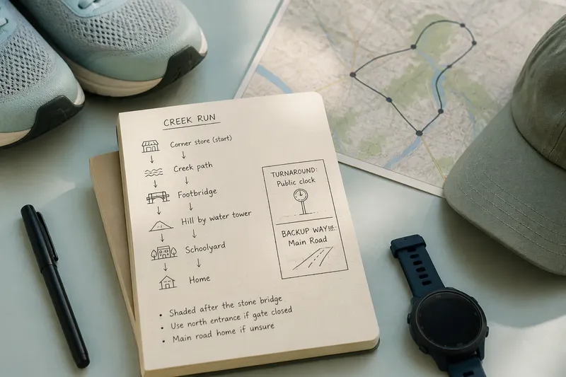
At the corner store, a runner turns at the red awning, follows the creek path to a footbridge, then heads home past the schoolyard. That kind of landmark-based running route is easy to describe and remember, even without making a claim about how runners in the past measured distance.
What does a route name help you remember?
A name like “the creek run” can hold a whole route in a few words. It might mean the path beside the water, the footbridge, and the quiet street back to the starting point. Ask another runner nearby and the phrase may mean something slightly different.
That looseness can be useful. “Take the mill road and come back past the library” gives a route a shape while leaving room to adjust for a closed gate, a busy sidewalk, or muddy footing.
Names also attach memories to places. A runner might remember the hill by the old water tower or the stretch where the trees meet overhead. The route name keeps those details close, even if nobody has discussed its exact length.
When you borrow a local route name, ask what it includes. The same name can point to different starts or turnarounds.
Which landmarks make a route easier to follow?
Useful landmarks are easy to recognize while moving and unlikely to be confused with the next block. A stone bridge, playground entrance, public clock, or distinctive trail junction can work. A particular mailbox is less dependable: it could be removed, and it is easy to miss at pace.
A sequence is more helpful than a single destination. The park gate, footbridge, hilltop, then water fountain gives you a mental route map. It can also help you notice a missed turn before the landscape feels unfamiliar.
- Check visibility: If you can spot a building, bridge, or trail junction from the approach, use it as a cue; if not, choose a clearer feature.
- Check access: If the reference point is a public library or park entrance, it is easier to describe and reach; if it is a private driveway, use a public place instead.
- Check the turnaround: If you can name the feature where you turn back, include it in your route note; if you cannot, ask the person who shared the route before setting out.
- Check permanence: If a cue depends on a seasonal feature such as a flowering tree, pair it with a fixed sign or path junction; if there is no fixed cue nearby, pick another landmark.
- Check the return: If the route has a recognizable way back from the far point, note it; if it does not, identify a main road or public place before you go.
- Check the sequence: If the landmarks follow a clear order, write them down in that order; if two turns are easy to confuse, add a street name or another visible cue.
For a route you plan to share, jot the landmarks in order in a pocket notebook or phone note. A short sequence is easier to remember than a long street-by-street description.
How can you describe distance without relying on a display?
Everyday descriptions often use familiar destinations: “to the reservoir and back,” “around the college grounds,” or “the long way through the neighborhood.” These phrases communicate the route’s shape and relative scale to people who know the area, but they do not establish an exact distance.
Repeated routes can develop a familiar rhythm. The cemetery wall may mark the early stretch, the steep street may come later, and the bakery may signal the final turn. The sequence gives a run a beginning, middle, and return without requiring a number.
Say you move to a town where a running group invites you on “the ridge road.” You ask for the start and turnaround, and someone points out the wooden gate above the last houses. You write down the gate, the trail junction before it, and the main road back. On the first outing, those cues help you follow the group; afterward, you can describe the route without claiming to know its exact length.
What should you ask before following a local route?
Where does the route actually start?
A route name may assume a familiar meeting point, such as a park entrance or shop corner. Confirm the start, especially if the route has several access points.
Which landmark marks the turnaround?
Ask what feature you should reach before heading back, and what comes just before it. A clear sequence can help prevent a confident wrong turn.
Does the route change with the season?
Some paths become muddy, dark, or overgrown at certain times of year. Ask whether the usual landmark stays visible and whether runners use a different street or trail when conditions change.
What should I do if I lose the route?
Learn a main road, transit stop, or public place nearby that you can recognize. If the route becomes unclear, pause somewhere safe and choose a familiar way back rather than guessing at a turn.
How do you make a useful route note?
Record the start, landmarks in order, the turnaround, and any point where the surface or direction changes. Add practical details such as “shaded after the stone bridge” or “use the north entrance if the gate is closed.” Those notes help another runner picture the route and decide whether it suits the day.
Write for a future version of yourself. “Big tree” may seem obvious now; “large oak beside the path junction” will make more sense after the leaves fall. If a cue is temporary, connect it to something fixed nearby.
Imagine your usual park gate is closed on a morning you planned to run the creek path. Your note says to enter by the north gate, pass the stone bridge, and turn back at the public clock; it also names the main road as a way home. You take the north entrance, follow the listed sequence, and reach the clock without using the closed gate. If the north entrance is also blocked, the note gives you a clear decision: take the main road home instead of searching for an unfamiliar trail entrance.
Why do landmark-based running routes still matter?
Landmarks make route-sharing conversational. A local runner can explain the way in ordinary language, and a newcomer can ask follow-up questions without needing the same device or app. The exchange passes along practical neighborhood knowledge, including which entrance stays open and where the path meets a main road.
A route can also be easier to recall when it has a few memorable features. “The run with the footbridge and windy ridge” gives you a vivid cue, while a bare distance figure says little about what you will see. A GPS watch or map can still be useful; landmark knowledge adds another way to understand where you are.
When someone describes a run by a creek, school, or water tower, ask which feature marks the turn. That one detail can turn a local phrase into a route you can follow and explain.